
Where survey-grade millimeters meet tape and total-station tolerances
Last updated:
Key takeaways:
- , usually within a few millimeters.
- Accuracy depends on range, registration, and surfaces.
- Far more complete and reliable than manual measuring.
“How accurate is 3D laser scanning?” is usually the first question a building owner, engineer, or contractor asks before commissioning a scan — and rightly so. Accuracy determines whether you can trust the data enough to design, fabricate, and build from it. The good news is that professional terrestrial laser scanning is extraordinarily precise. The more useful answer, though, requires understanding what “accuracy” actually means, what affects it, and how much precision your particular project really needs.
This guide explains laser scanning accuracy in practical terms: the numbers you can expect, the difference between related terms that are often confused, the factors that help or hurt precision, and how to make sure the accuracy you pay for matches the decisions the data must support.

The short answer: , 2 to 4 millimeters
A professional terrestrial laser scanner capturing a building under normal conditions typically achieves accuracy in the range of 2 to 4 millimeters. That means a measured point sits within a few millimeters of its true real-world location. For context, that is dramatically tighter than tape-and-clipboard field measurement, and far more than sufficient for architecture, MEP coordination, structural work, and virtually all commercial construction.
To put it in perspective, the width of a few stacked sheets of paper is roughly the margin we are talking about across an entire room or facade. This is why scan data is trusted as a legal and engineering record of existing conditions, and why prefabricated components built from good scan data fit when they arrive on site.
Accuracy, precision, and resolution are not the same thing
Three terms get used interchangeably but mean different things, and confusing them leads to bad decisions.
- Accuracy is how close a measurement is to the true value. A scanner is accurate if the point it records matches reality.
- Precision is how repeatable a measurement is. A scanner is precise if it returns the same result every time, even if that result is slightly off from the truth.
- Resolution is how densely points are spaced — how much detail is captured. High resolution means points are close together, capturing fine features, but it is not the same as being accurate.
A dataset can be dense but inaccurate, or accurate but sparse. What you usually want is a balance: enough accuracy to trust the measurements and enough resolution to see the features that matter for your project.
What affects laser scanning accuracy
Several factors determine how accurate a final point cloud is, and understanding them helps you judge quality and set expectations.
The scanner and ranging method

Professional scanners use time-of-flight or phase-shift ranging. Phase-shift instruments deliver very high precision at shorter ranges, while time-of-flight instruments reach longer distances. The instrument’s specifications set the baseline for what is achievable, but the way it is used matters just as much.
Registration quality
A building is captured from many scan positions that must be aligned, or registered, into one coordinate system. Registration is where accuracy is often won or lost. Clean registration with low, consistent error keeps the whole dataset trustworthy; sloppy registration introduces doubling and drift that no downstream modeling can fully repair. This is one of the biggest differences between an experienced provider and an inexperienced one.
Distance, angle, and surface
Accuracy degrades as range increases and as the laser strikes surfaces at steep angles. Highly reflective, transparent, or very dark materials — glass, polished metal, black surfaces — can scatter or absorb the beam and reduce reliability. Skilled technicians plan scan positions to keep critical surfaces within optimal range and angle.
Environmental conditions

Vibration, heat shimmer, dust, and moving objects can all introduce noise. Interior building scans are usually a controlled environment; long-range outdoor and industrial scans require more care to manage these effects.
Matching accuracy to your project
More accuracy is not always better — it is a question of fit. Structural steel fit-up, equipment tie-ins, and precision manufacturing may demand the tightest tolerances the technology can deliver. Architectural as-builts, space planning, and renovation design are well served by standard capture. Virtual tours, rough volume estimates, and marketing visuals can tolerate lower density and looser tolerances. Paying for maximum precision on a project that does not need it wastes money; accepting loose data on a project that demands tight tolerances creates rework and field conflicts.
The right approach is to define the decisions the data must support first, then specify accuracy and resolution to match. A good scanning provider will ask what you are trying to accomplish before recommending settings, because that conversation is what ensures the deliverable actually fits.

How accuracy is verified
Reputable providers do not just assert accuracy — they demonstrate it. Registration reports document how well scans aligned, target-based checks compare measured control points to known values, and quality-control passes flag noise and gaps before delivery. Asking for a registration report and a clear statement of expected accuracy is a reasonable request, and a professional firm will provide it without hesitation.
Common questions about laser scanning accuracy

Is laser scanning more accurate than traditional surveying?
For capturing dense existing conditions, laser scanning provides vastly more measured detail than manual methods, at comparable or better accuracy. Traditional survey instruments remain valuable for establishing control and boundary work, and the two are often used together.
Does colorization affect accuracy?
No. Color is sampled from photographs and draped onto the points for visualization; it does not change the underlying measured geometry, which comes from the laser.
Do you document the accuracy of a scan?
Yes, on request. We can provide registration reports that show how closely the scans align, and we state the accuracy required for each project in USIBD Level of Accuracy terms before fieldwork begins.
Can I get millimeter accuracy on a whole building?

Yes, within the realistic limits of range and registration. Professional workflows routinely deliver a few millimeters of accuracy across an entire structure when the capture and registration are done properly.
Professional 3D laser scanning delivers documented accuracy of a few millimeters — precise enough to design, fabricate, and build from with confidence. Understanding what drives that accuracy helps you specify the right scan and trust the data you receive.
Why accuracy matters for your budget
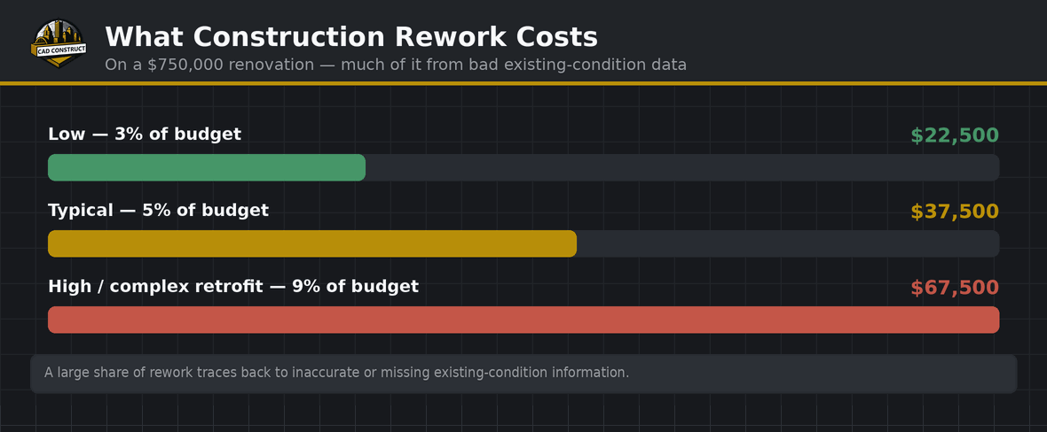
Accuracy is not an abstract technical spec — it is directly tied to money. On renovation and retrofit projects, the single biggest source of cost overruns is the gap between what old drawings say and what the building actually is. When a contractor fabricates ductwork, steel, or millwork based on inaccurate measurements, the pieces do not fit, and the rework, delays, and change orders that follow can dwarf the cost of the scan itself. Documented accuracy removes that risk by giving every trade a single, trustworthy source of truth.
The economics are especially favorable for prefabrication. When components are built off-site from accurate scan data, they arrive ready to install, compressing schedules and reducing on-site labor. That only works if the underlying measurements are tight — which is exactly what professional laser scanning provides.

Accuracy over distance: a practical picture
Laser scanning accuracy is strongest at moderate range and degrades gradually as distance grows. For typical interior spaces, where surfaces are well within the scanner’s optimal range, accuracy stays in the band throughout. For large open volumes — warehouses, atriums, industrial halls — a skilled technician adds scan positions to keep critical surfaces within range rather than capturing everything from a few distant setups. This is why a thoughtful scan plan matters more than raw instrument specifications: the same scanner can produce excellent or mediocre data depending on how it is deployed.
How to specify accuracy in your scope

When you commission a scan, state the accuracy you need and the decisions it must support, rather than leaving it implied. Ask the provider what accuracy they expect to achieve, how they will register the scans, and how they will verify the result. Request a registration report as part of the deliverable. A professional firm will welcome these questions, because clear expectations protect both sides and ensure the data you receive is genuinely fit for its purpose.
Real-world conditions that challenge accuracy
In the field, a few situations demand extra care to preserve accuracy. Highly reflective surfaces such as polished floors, mirrors, and glass curtain walls can scatter the laser and produce stray points, so technicians adjust settings or add targets to compensate. Very dark or matte-black materials absorb much of the beam and return weaker data, sometimes requiring closer scan positions. Long, narrow spaces like corridors and tunnels accumulate small registration errors over distance, which is why control targets or a total-station backbone are used to hold the geometry true end to end. Occupied and active sites introduce moving people and equipment that must be filtered out during processing. An experienced crew anticipates these conditions and plans around them, which is a large part of what separates dependable results from data that merely looks detailed.
None of these challenges are dealbreakers; they are simply reasons that method and experience matter. The same building scanned by a careful professional and by an untrained operator can yield very different accuracy, even with identical hardware. That is why owners should weigh a provider’s process and quality control as heavily as the equipment they advertise.
Related guides
Planning a project in the Pittsburgh region? CAD Construct LLC delivers 3D laser scanning, Scan-to-BIM, and virtual tours with field-verified accuracy. Request a scanning quote.


0 Comments