
Last updated:
Connecting separate scan setups into one aligned point cloud
Key takeaways:
- Aligns separate scans into one coordinated point cloud.
- Uses overlapping geometry (targetless) or physical targets.
- Registration quality determines the model’s overall accuracy.
Registration is how individual laser scans are aligned into one accurate model — the step that determines documented accuracy.
A single scan from one position only captures what the scanner can see from that spot. Real buildings and sites have walls, corners, and clutter that block the view, so capturing a complete space takes many scans from many positions. Registration is the process of aligning all of those individual scans into one seamless, unified point cloud — stitching the separate viewpoints together so they share a single coordinate framework.
It is one of the most important steps in the entire scan-to-BIM pipeline, because the accuracy of the registration sets a ceiling on everything built from the data afterward.
Aligning many scans into one
Think of each scan position as a photograph taken from a different spot in a room. Individually they overlap but do not line up; registration is what rotates and positions each one so the overlapping areas match perfectly and the whole space becomes one continuous dataset. There are three common ways to achieve this:
- Cloud-to-cloud (targetless) registration matches overlapping geometry between scans. Software finds common surfaces and aligns them, so no physical markers are needed. It relies on generous overlap and enough distinctive shape to lock onto.
- Target-based registration uses physical reference targets — spheres or checkerboards — placed in the scene and captured by multiple scans. The software aligns the shared targets, which is fast and reliable in feature-poor spaces like long corridors.
- Survey-based registration ties scans to surveyed control points with known coordinates, which also georeferences the data to the real world.
Many projects blend these methods, using targets or survey control where geometry alone would be ambiguous.
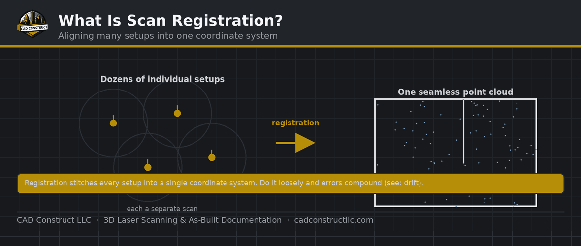
A building is captured from many scanner positions. Registration stitches those individual scans into a single coordinate system. The tighter the registration, the more accurate the final point cloud — typically 2–4 mm.
Why it matters
Registration quality is inherited by everything downstream. If scans are aligned with half an inch of drift between them, the “unified” cloud actually contains that error, and any model traced from it carries the same inaccuracy no matter how careful the modeler is. Good registration produces a tight, coherent cloud; poor registration produces blurred or doubled surfaces where scans nearly — but not quite — agree.
This is why reputable providers generate a registration report documenting how closely the scans align, usually expressed in millimeters or fractions of an inch. That number is effectively the accuracy budget for the project, and sharing it gives the design team confidence in the data they are building on. When you receive scan data, the registration report is one of the first things worth asking for.
Good registration is what makes a scan trustworthy for BIM, fabrication, and coordination. Learn how accuracy works.
The role of overlap
Successful registration depends on overlap — the shared area captured by neighboring scans. Cloud-to-cloud methods in particular need enough common geometry to find a confident match, which is why scan positions are planned so each one sees a generous slice of what its neighbors saw. Too little overlap, or overlap in a featureless area like a blank corridor, leaves the software guessing. Good field planning — deciding where to set up before scanning begins — is what makes clean registration possible later.

Targets vs. targetless registration
Targetless (cloud-to-cloud) registration is faster in the field because there is nothing to place, and it works well in spaces with distinctive geometry. Target-based registration adds setup time but shines in repetitive or feature-poor environments where geometry alone is ambiguous — long hallways, empty warehouses, symmetrical rooms. Neither is universally better; experienced crews choose based on the space, and often use targets selectively to reinforce a mostly targetless workflow.
Software used for registration
Registration happens in specialized software. Autodesk ReCap handles it within the Autodesk ecosystem, while scanner manufacturers offer their own tools — Leica Cyclone (and Cyclone REGISTER), FARO SCENE, and Trimble RealWorks among them. These packages align the scans, report the resulting accuracy, and export the unified cloud in formats like RCP/RCS or E57 for downstream modeling. The tool matters less than the skill and diligence of the person running it.
What good registration looks like
A well-registered cloud shows crisp, single surfaces — walls are one clean plane, not two slightly offset copies. Edges are sharp, and moving through the data reveals no ghosting or doubling. The registration report backs this up with a low alignment error. When you open a cloud and features look doubled or fuzzy, that is registration error you are seeing, and it is a signal to question the data before modeling on it.

Common registration mistakes to avoid
- Insufficient overlap. Scans that share too little geometry are hard to align confidently.
- Feature-poor setups without targets. Blank, symmetrical spaces need targets or control to register reliably.
- Skipping the accuracy report. Without it, nobody knows how good the alignment really is.
- Ignoring coordinates. Decide early whether the registered cloud needs real-world coordinates.
The registration workflow, step by step
On a typical project, registration follows a clear sequence. In the field, the crew plans scan positions for good overlap and places any targets. Back in the office, the individual scans are imported into registration software, which performs an initial alignment — automatically for cloud-to-cloud, or via matched targets. The technician then reviews the result, refines any weak links, and checks the accuracy report. Once the alignment meets the required tolerance, the unified cloud is cleaned of noise and exported for modeling. Skipping or rushing the review stage is where most registration problems originate.

How registration affects project cost and schedule
Registration is real work, and it is part of what you pay for in a scanning engagement. Well-planned capture with good overlap registers quickly and cleanly; poorly planned capture can require hours of manual alignment or, worse, a return trip to fill gaps. This is one reason experienced providers invest in field planning — time saved in registration and modeling usually far outweighs the extra care taken during capture. When comparing quotes, remember that thorough registration and a documented accuracy report are signs of quality, not padding.
Why registration is worth getting right
Because every drawing, model, and measurement derived from a scan inherits the registration beneath it, this step quietly determines whether the final deliverable can be trusted. A tight, well-documented registration gives designers and contractors confidence to build against the data; a sloppy one seeds errors that surface expensively during construction. It is the foundation the rest of the scan-to-BIM process stands on.
Registration and the rest of your data
Once scans are registered, the unified cloud becomes the single source everything else draws from — as-built models, 2D drawings, sections, meshes, and virtual tours. Getting this step right means each of those deliverables starts from the same accurate foundation, so they agree with one another and with the building itself. It is the quiet hinge on which a dependable scan-to-BIM project turns.
Related reading
3D Laser Scanning vs. Photogrammetry vs. Drones: Which Is Right for Your Project?
FAQ
Does registration affect accuracy? Yes — it is the main driver of whole-project accuracy.
How is it done? Via targets, cloud-to-cloud matching, or survey control.
What is registration in simple terms?
Aligning multiple individual laser scans into one unified point cloud so they share a single, consistent coordinate framework.
What is the difference between registration and georeferencing?
Registration aligns scans to each other. Georeferencing then ties that aligned cloud to real-world coordinates using surveyed control points.
Do I need targets to register scans?
Not always. Cloud-to-cloud registration uses overlapping geometry and needs no targets, but targets or survey control help in feature-poor or highly repetitive spaces.
How accurate is registration?
Good terrestrial registration is typically within a few millimeters. The registration report documents the actual figure, which sets the accuracy ceiling for the project.
Why does my point cloud look doubled or blurry?
That is usually registration error — scans that nearly but not quite align. It is a sign to review the registration before modeling from the data.
Can scans be re-registered later?
Yes. Because the individual scans are preserved, data can be re-registered or refined if needed — for example to improve accuracy or add new scans to an existing dataset.
How long does registration take?
It depends on the number of scans and how well they overlap. Clean, well-planned capture can register in a few hours; large or poorly overlapped projects take considerably longer.
Who performs the registration?
The scanning provider’s processing technician, using specialized software. It is a skilled office task that follows the field capture, not something the client needs to handle.
Does more overlap always mean better registration?
Generally yes, up to a point — generous overlap gives the software more common geometry to match, which improves reliability. Beyond that, the quality and distinctiveness of the overlapping features matter more than sheer quantity.
Get field-verified existing conditions in Pittsburgh
CAD Construct LLC delivers 3D laser scanning, as-built drawings, scan-to-BIM, and 360° virtual tours across Pittsburgh & Western PA. Request a free quote or call (800) 967-2627.


0 Comments